
File:Easter Island map-en.svg

Size of this PNG preview of this SVG file: 800 × 569 piksel. weerngooji: goɗɗi 320 × 228 piksel | 640 × 455 piksel | 1 024 × 729 piksel | 1 280 × 911 piksel | 2 560 × 1 821 piksel | 1 750 × 1 245 piksel.
Fiilde asliire (Fiilde SVG, werngo mum ko 1 750 × 1 245 pikelle, ɓetol fiildee: 878 KB)
Tonngol
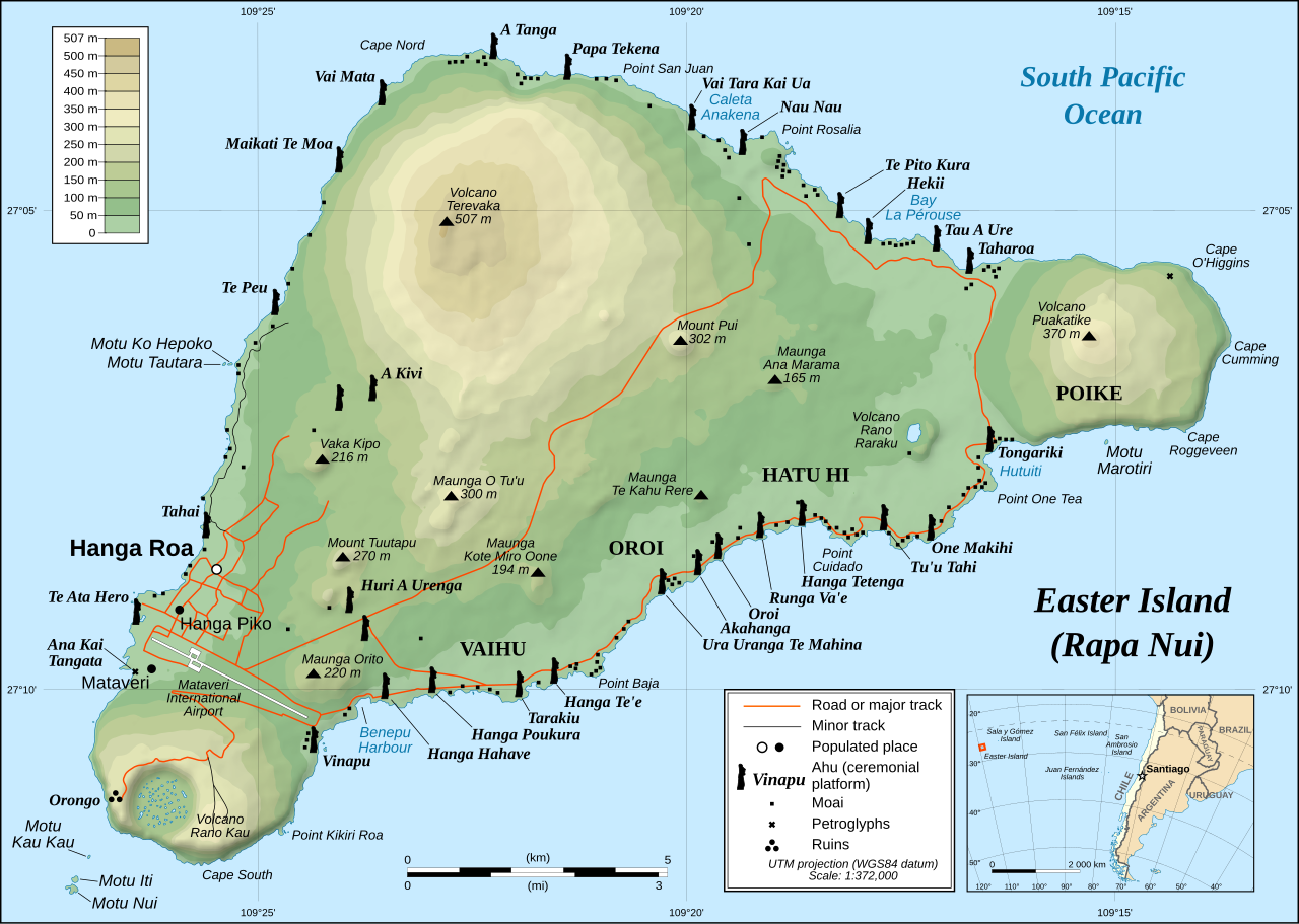
This image was selected as picture of the day on Wikimedia Commons for 1 December 2008. It was captioned as follows: English: Detailed topographic map in English of Easter Island. Other languages:
Afrikaans: Gedetaileerde topografie van Paaseiland Català: Mapa topogràfic detallat en anglès de l'Illa de Pasqua. Čeština: Detailní topografická mapa Velikonočního ostrova Eesti: Detailne inglisekeelne topograafiline kaart et:Lihavõttesaarest. English: Detailed topographic map in English of Easter Island. Esperanto: detala topografia mapo de la Paskinsulo (jen anglalingva, sed ankaŭ havebla en pluraj aliaj lingvoj) Français : Carte topographique détaillée en anglais de l'île de Pâques Italiano: Mappa topografica dell'Isola di Pasqua, Cile. Nederlands: Engelstalige gedetailleerde topografische kaart van Paaseiland Português: Mapa topográfico detalhado, em Inglês, da Ilha da Páscoa Română: Hartă topografică detaliată, în limba engleză, a insulei Paștelui. Svenska: Detaljerad topografisk karta på engelska över Påskön. Македонски: Детална топографска карта на Велигденскиот Остров на англиски. Русский: Топографическая карта Острова Пасхи 한국어: 이스터 섬의 지형도. 中文: 复活节岛地形图 中文(繁體): 復活節島地形圖 |
|

| Cifagol |
English: Detailed topographic map in English of Easter Island
Français : Carte topographique détaillée en anglais de l'île de Paques
Português: Mapa topográfico detalhado, em Inglês, da Ilha da Páscoa.
|
| Ñalngu | October 2007 - October 2008 for the new version (see the release note) |
| Sewnde |
Own work
|
| Binnduɗo | Eric Gaba (Sting), translated by Bamse |
| Jamirol (Kuuttoragol ndee fiilde) |
Creative Commons: Share Alike – attribution required |
| Other versions |
[]
|


![[1]](http://www.waymarker.co.uk/ml/rapanui/map.jpg)
This W3C-unspecified vector image was created with Inkscape .

|
This SVG file contains embedded text that can be translated into your language, using any capable SVG editor, text editor or the SVG Translate tool. For more information see: About translating SVG files. |
Jamirooje
I, the copyright holder of this work, hereby publish it under the following license:
This file is licensed under the Creative Commons Attribution-Share Alike 2.5 Generic license.
- Aɗa wellitii:
- e lollinde – e tummbitaade, saakde e ɓenninde golle ɗee
- e muultaade – e jaaɓtinde
- E ɗii-ɗoo sarɗiiji:
- fe'inana – You must give appropriate credit, provide a link to the license, and indicate if changes were made. You may do so in any reasonable manner, but not in any way that suggests the licensor endorses you or your use.
- lollin nannduɗe – If you remix, transform, or build upon the material, you must distribute your contributions under the same or compatible license as the original.
Aslol fiilde
Dobo e ñalngu/waktu ngam yiyde fiilde ndee no nde yaltirta e oon waktu nih.
| Ñalngu/Waktu | Dooɓre | Ɓete | Kuutoro | Yowre | |
|---|---|---|---|---|---|
| gonaaɗo | 22:51, 11 Siilo 2023 | | 1 750 × 1 245 (878 KB) | Tseng,Lu-Yen | Reverted to version as of 12:43, 22 October 2008 (UTC) |
| 07:17, 10 Bowte 2011 |  | 1 750 × 1 245 (1,92 MB) | Hel-hama | Text appearance improved using Inkscape. | |
| 12:43, 22 Yarkomaa 2008 |  | 1 750 × 1 245 (878 KB) | Sting | Completely new version of the map ; new standard colors | |
| 01:06, 30 Yarkomaa 2007 |  | 1 750 × 1 245 (536 KB) | Sting | Some additional info | |
| 00:37, 19 Yarkomaa 2007 |  | 1 750 × 1 245 (534 KB) | Bamse | ||
| 00:14, 19 Yarkomaa 2007 |  | 1 750 × 1 245 (534 KB) | Bamse | {{Information |Description= |Source=self-made |Date= |Author= Bamse }} == Summary == {{Information| |Description=Detailed topographic map in English of Easter island |Source=Own work, translation of Image:Easter Island map-fr.svg<b |
Kuutorgol fiilde
Alaa kelle kuutotooɗe ndee fiilde.
Kuutoragol fiilde kuuɓtidinngol
Wikiiji ɗii-ɗoo goɗɗi ena kuutoroo ndee fiilde:
- Kuutoragol e af.wikipedia.org
- Kuutoragol e ami.wikipedia.org
- Kuutoragol e ar.wikipedia.org
- Kuutoragol e az.wikipedia.org
- Kuutoragol e bcl.wikipedia.org
- Kuutoragol e bn.wikipedia.org
- Kuutoragol e ca.wikipedia.org
- Kuutoragol e ckb.wikipedia.org
- Kuutoragol e da.wikipedia.org
- Kuutoragol e de.wikipedia.org
- Kuutoragol e el.wikipedia.org
- Kuutoragol e en.wikipedia.org
- Cartography
- Easter Island
- Hanga Roa
- Mu (mythical lost continent)
- Moai
- Motu Nui
- Map coloring
- Rapa Nui National Park
- Hanau epe
- Orongo
- Ahu Tongariki
- Poike
- Rano Kau
- Terevaka
- Ahu Akivi
- List of active separatist movements in Oceania
- User:ISaveNewspapers/sandbox
- Isla de Pascua (commune)
- Portal:Geodesy
- User:Iamojo/testcase/EasterIsland
- User:Iamojo/testcase/EasterIsland short
- Kuutoragol e en.wikiversity.org
- Kuutoragol e en.wikivoyage.org
- Kuutoragol e es.wikipedia.org
- Kuutoragol e et.wikipedia.org
- Kuutoragol e fa.wikipedia.org
- Kuutoragol e frr.wikipedia.org
- Kuutoragol e fr.wikipedia.org
Yiy jokkol kuutoragol kuuɓtidingol ngoo hello.