
File:Mali-CIA WFB Map.png
Werngo ɓurngo ɗoo toowde alaa.
Mali-CIA_WFB_Map.png (330 × 353 piksele, ɓetol fiilde: 19 KB, mbaydi MIME: image/png)
Tonngol
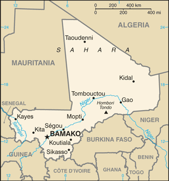
updated map of Mali from the CIA World Factbook - 24 July 2008 edition: https://www.cia.gov/library/publications/the-world-factbook/maps/ml-map.gif
- See also the 2004 version.
.png)
This image is in the public domain because it contains materials that originally came from the United States Central Intelligence Agency's World Factbook.
|
 |
Aslol fiilde
Dobo e ñalngu/waktu ngam yiyde fiilde ndee no nde yaltirta e oon waktu nih.
| Ñalngu/Waktu | Dooɓre | Ɓete | Kuutoro | Yowre | |
|---|---|---|---|---|---|
| gonaaɗo | 02:15, 26 Morso 2008 | | 330 × 353 (19 KB) | Hoshie | updated map of Mali from the CIA World Factbook - 24 July 2008 edition: https://www.cia.gov/library/publications/the-world-factbook/maps/ml-map.gif |
| 09:16, 27 Mbooy 2005 |  | 350 × 376 (11 KB) | Wolfman~commonswiki | {{CIA-map}} |
Kuutorgol fiilde
3 Ɗee kelle ena kuutoroo ndee fiilde:
Kuutoragol fiilde kuuɓtidinngol
Wikiiji ɗii-ɗoo goɗɗi ena kuutoroo ndee fiilde:
- Kuutoragol e arz.wikipedia.org
- Kuutoragol e ca.wikipedia.org
- Kuutoragol e el.wikipedia.org
- Kuutoragol e en.wikipedia.org
- Kuutoragol e en.wikisource.org
- Kuutoragol e ilo.wikipedia.org
- Kuutoragol e ja.wikipedia.org
- Kuutoragol e kn.wikipedia.org
- Kuutoragol e lt.wiktionary.org
- Kuutoragol e ml.wikipedia.org
- Kuutoragol e pl.wikipedia.org
- Kuutoragol e simple.wikipedia.org
- Kuutoragol e si.wikipedia.org
- Kuutoragol e sl.wikipedia.org
- Kuutoragol e th.wikipedia.org
- Kuutoragol e uz.wikipedia.org