
File:Mbini.PNG
Fiilde asliire (1 918 × 1 382 piksele, ɓetol fiilde: 998 KB, mbaydi MIME: image/png)
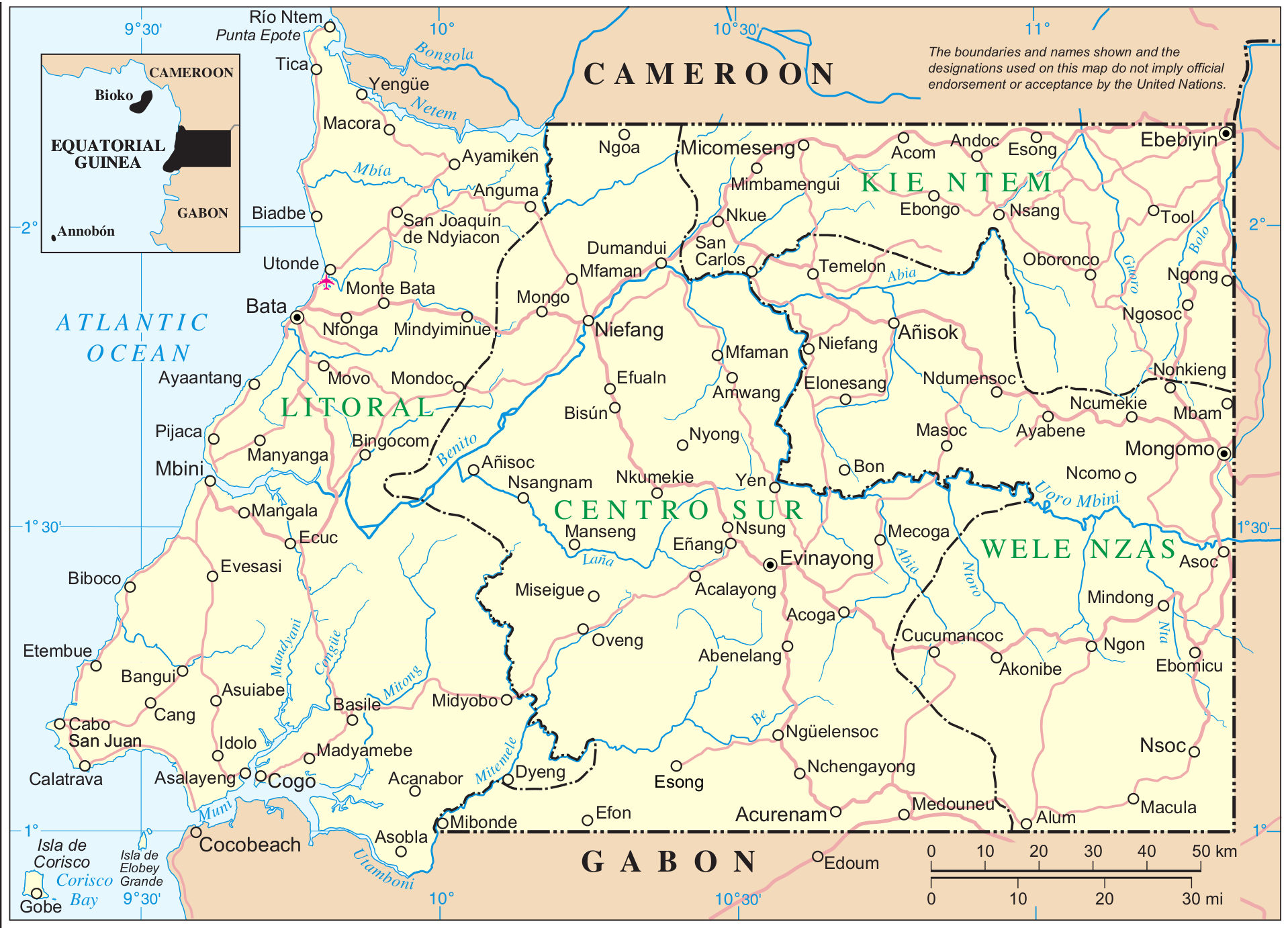
Mapa de Mbini. Guinea Ecuatorial
| This image is a map derived from a United Nations map.
Unless stated otherwise, UN maps are to be considered in the public domain. This applies worldwide. UN maps are, in principle, open source material and you can use them in your work or for making your own map. UN requests however that you delete the UN name, logo and reference number upon any modification to the map. Content of your map will be your responsibility. You can state in your publication, if you wish, something like: based on UN map … (map name, map number, revision number and date). See: Geospatial Information Section. And: Geospatial, location data for a better world. |
 |
Fuente: http://www.un.org/Depts/Cartographic/map/profile/eqguinea.pdf
Aslol fiilde
Dobo e ñalngu/waktu ngam yiyde fiilde ndee no nde yaltirta e oon waktu nih.
| Ñalngu/Waktu | Dooɓre | Ɓete | Kuutoro | Yowre | |
|---|---|---|---|---|---|
| gonaaɗo | 11:12, 7 Siilto 2014 | | 1 918 × 1 382 (998 KB) | Basquetteur | Higher resolution map |
| 03:49, 20 Duujal 2005 |  | 844 × 606 (142 KB) | Taichi | Mapa de Mbini. Guinea Ecuatorial {{PD}} Fuente: http://www.un.org/Depts/Cartographic/map/profile/eqguinea.pdf |
Kuutorgol fiilde
Ngoo hello ena huutoroo ndee fiilde:
Kuutoragol fiilde kuuɓtidinngol
Wikiiji ɗii-ɗoo goɗɗi ena kuutoroo ndee fiilde:
- Kuutoragol e af.wikipedia.org
- Kuutoragol e an.wikipedia.org
- Kuutoragol e ast.wikipedia.org
- Kuutoragol e bg.wikipedia.org
- Kuutoragol e ca.wikipedia.org
- Kuutoragol e de.wikipedia.org
- Kuutoragol e de.wikivoyage.org
- Kuutoragol e en.wikipedia.org
- Kuutoragol e eo.wikipedia.org
- Kuutoragol e es.wikipedia.org
- Kuutoragol e eu.wikipedia.org
- Kuutoragol e fi.wikipedia.org
- Kuutoragol e fr.wikipedia.org
- Kuutoragol e fr.wiktionary.org
- Kuutoragol e gl.wikipedia.org
- Kuutoragol e ha.wikipedia.org
- Kuutoragol e hr.wikipedia.org
- Kuutoragol e ig.wikipedia.org
- Kuutoragol e it.wikipedia.org
- Kuutoragol e it.wikivoyage.org
- Kuutoragol e ja.wikipedia.org
- Kuutoragol e ka.wikipedia.org
- Kuutoragol e ko.wikipedia.org
- Kuutoragol e lt.wikipedia.org
Yiy jokkol kuutoragol kuuɓtidingol ngoo hello.