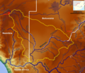
File:Molopo Basin OSM.png
Appearance

Ɓetol ngol jiytol: 694 × 599 piksel. weerngooji: goɗɗi 278 × 240 piksel | 556 × 480 piksel | 890 × 768 piksel | 1 186 × 1 024 piksel | 2 372 × 2 048 piksel | 7 183 × 6 202 piksel.
Fiilde asliire (7 183 × 6 202 piksele, ɓetol fiilde: 38,72 MB, mbaydi MIME: image/png)
Aslol fiilde
Dobo e ñalngu/waktu ngam yiyde fiilde ndee no nde yaltirta e oon waktu nih.
| Ñalngu/Waktu | Dooɓre | Ɓete | Kuutoro | Yowre | |
|---|---|---|---|---|---|
| gonaaɗo | 08:15, 24 Siilo 2023 |  | 7 183 × 6 202 (38,72 MB) | Peter in s | Kontrast |
| 12:51, 16 Juko 2020 |  | 8 071 × 6 969 (44,15 MB) | Peter in s | {{Information |description ={{en|1=The Molopo River Basin (OSM)}} |date =2020-08-16 |source =https://maps-for-free.com |author =Hans Braxmeier & Peter in s }} {{cc-by-sa-2.0}} Category:Maps of the Oranje Drainage basin Category:Molopo River |
Kuutorgol fiilde
Ngoo hello ena huutoroo ndee fiilde:
Kuutoragol fiilde kuuɓtidinngol
Wikiiji ɗii-ɗoo goɗɗi ena kuutoroo ndee fiilde:
- Kuutoragol e ceb.wikipedia.org
- Kuutoragol e de.wikipedia.org
- Kuutoragol e en.wikipedia.org
- Kuutoragol e fi.wikipedia.org
- Kuutoragol e it.wikipedia.org
- Kuutoragol e pt.wikipedia.org
- Kuutoragol e sw.wikipedia.org
- Kuutoragol e uk.wikipedia.org
- Kuutoragol e uz.wikipedia.org
- Kuutoragol e xmf.wikipedia.org
