
File:Mweru-Luapula.jpg
Ɓetol ngol jiytol: 250 × 599 piksel. weerngooji: goɗɗi 100 × 240 piksel | 396 × 949 piksel.
Fiilde asliire (396 × 949 piksele, ɓetol fiilde: 79 KB, mbaydi MIME: image/jpeg)
Tonngol
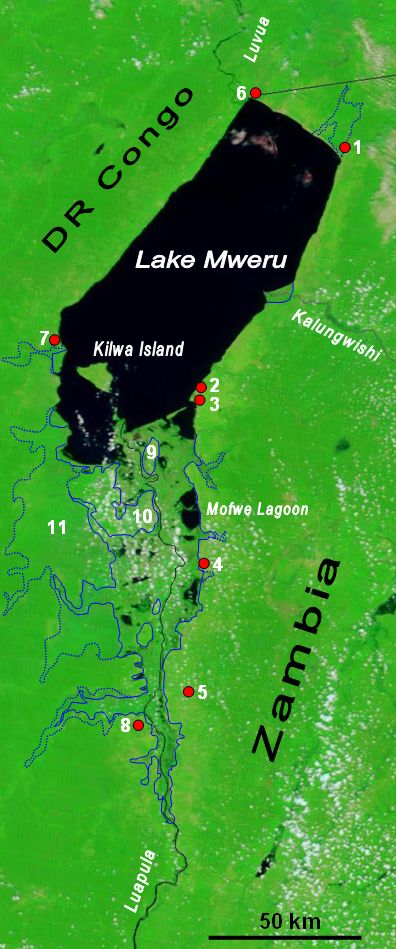
| Cifagol | The lower Luapula River, its delta where it enters Lake Mweru, and Mweru's outlet, the Luvua River going on north to the Lualaba and Congo rivers. Water shows up as black in this false-colour NASA satellite image. The extent of the Luapula Swamps is shown by the solid blue line, and the extent of the floodplain is shown as a dotted line. The towns are, in Zambia: 1 Chiengi, 2 Kashikishi, 3 Nchelenge, 4 Mwansabombwe, 5 Mwense; in DR Congo: 6 Pweto, 7 Kilwa, 8 Kasenga. Other features: 9 Chisenga Island, 10 the largest swamp island (in DR Congo), 11 the main floodplain. |
| Ñalngu | |
| Sewnde | Image NASA Visible Earth website, overlay in Word |
| Binnduɗo | NASA credit Jacques Descloitres, MODIS Rapid Response Team, NASA/GSFC; overlay by User:Rexparry_sydney |
| Jamirol (Kuuttoragol ndee fiilde) |
NASA public domain and my permission for overlay to also be Public Domain. |
Jamirooje
| This file is in the public domain in the United States because it was solely created by NASA. NASA copyright policy states that "NASA material is not protected by copyright unless noted". (See Template:PD-USGov, NASA copyright policy page or JPL Image Use Policy.) | ||
 |
Warnings:
|
Aslol fiilde
Dobo e ñalngu/waktu ngam yiyde fiilde ndee no nde yaltirta e oon waktu nih.
| Ñalngu/Waktu | Dooɓre | Ɓete | Kuutoro | Yowre | |
|---|---|---|---|---|---|
| gonaaɗo | 03:51, 28 Mbooy 2007 | | 396 × 949 (79 KB) | Rexparry sydney~commonswiki | {{Information |Description=The lower Luapula River, its delta where is enters Lake Mweru, and Mweru's outlet, the Luvua River going on north to the Lualaba and Congo rivers. Water shows up as black in this false-colour NASA satellite image. The extent of |
Kuutorgol fiilde
Ngoo hello ena huutoroo ndee fiilde:
Kuutoragol fiilde kuuɓtidinngol
Wikiiji ɗii-ɗoo goɗɗi ena kuutoroo ndee fiilde:
- Kuutoragol e af.wikipedia.org
- Kuutoragol e ar.wikipedia.org
- Kuutoragol e bg.wikipedia.org
- Kuutoragol e ca.wikipedia.org
- Kuutoragol e ceb.wikipedia.org
- Kuutoragol e da.wikipedia.org
- Kuutoragol e de.wikipedia.org
- Kuutoragol e en.wikipedia.org
- Kuutoragol e es.wikipedia.org
- Kuutoragol e fa.wikipedia.org
- Kuutoragol e ha.wikipedia.org
- Kuutoragol e hu.wikipedia.org
- Kuutoragol e incubator.wikimedia.org
- Kuutoragol e it.wikipedia.org
- Kuutoragol e ka.wikipedia.org
- Kuutoragol e nl.wikipedia.org
- Kuutoragol e no.wikipedia.org
- Kuutoragol e pl.wikipedia.org
- Kuutoragol e ru.wikipedia.org
- Kuutoragol e rw.wikipedia.org
- Kuutoragol e simple.wikipedia.org
- Kuutoragol e sr.wikipedia.org
- Kuutoragol e sv.wikipedia.org
- Kuutoragol e sw.wikipedia.org
- Kuutoragol e www.wikidata.org
- Kuutoragol e zh.wikipedia.org