Jump to content

File:Topographic map of Gabon-fr.svg

Page contents not supported in other languages.
Iwde to Wikipedia

Fiilde asliire(Fiilde SVG, werngo mum ko 815 × 965 pikelle, ɓetol fiildee: 1,69 MB)

Ndee fiilde ummii ko e Wikimedia Commons tee ena waawi huutoreede e eɓɓooje koɗe. Cifol gonngol e file description page makko ena holliraa les ɗoo.

Image of the year
Image of the year
Featured image

Wikimedia Commons

This is a featured picture on Wikimedia Commons (Featured pictures) and is considered one of the finest images. See its nomination here.

If you have an image of similar quality that can be published under a suitable copyright license, be sure to upload it, tag it, and nominate it.

Tonngol

Cifagol
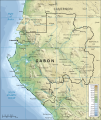
Français : Carte topographique du Gabon.
Ñalngu (English version); 2008-04-03 (French translation)
Sewnde Traduction de Image:Topographic map of Gabon-en.svg
Binnduɗo Mysid (English version); Bourrichon (French translation)
Other versions

Derivative works of this file:

[wallifaade]

SVG genesis
InfoField
 
The SVG code is valid.
 
This map was created with Inkscape, or with something else.
Translate this file This SVG file contains embedded text that can be translated into your language, using any capable SVG editor, text editor or the SVG Translate tool. For more information see: About translating SVG files.

Jamirooje

I, the copyright holder of this work, hereby publish it under the following licenses:
GNU head Permission is granted to copy, distribute and/or modify this document under the terms of the GNU Free Documentation License, Version 1.2 or any later version published by the Free Software Foundation; with no Invariant Sections, no Front-Cover Texts, and no Back-Cover Texts. A copy of the license is included in the section entitled GNU Free Documentation License.
w:en:Creative Commons
fe'inana lollin nannduɗe
This file is licensed under the Creative Commons Attribution-Share Alike 4.0 International, 3.0 Unported, 2.5 Generic, 2.0 Generic and 1.0 Generic license.
Aɗa wellitii:
  • e lollinde – e tummbitaade, saakde e ɓenninde golle ɗee
  • e muultaade – e jaaɓtinde
E ɗii-ɗoo sarɗiiji:
  • fe'inana – You must give appropriate credit, provide a link to the license, and indicate if changes were made. You may do so in any reasonable manner, but not in any way that suggests the licensor endorses you or your use.
  • lollin nannduɗe – If you remix, transform, or build upon the material, you must distribute your contributions under the same or compatible license as the original.
Aɗa waawi labaade jamirol cuɓi-ɗaa.

Captions

Add a one-line explanation of what this file represents
Topographical map of Gabon

Items portrayed in this file

depicts Engeleere

map Engeleere

topography Engeleere

topographic map Engeleere

copyright status Engeleere

copyrighted Engeleere

16 Colte 2008

Aslol fiilde

Dobo e ñalngu/waktu ngam yiyde fiilde ndee no nde yaltirta e oon waktu nih.

Ñalngu/WaktuDooɓreƁeteKuutoroYowre
gonaaɗo14:21, 3 Seeɗto 2008Dooɓre yamre 14:21, 3 Seeɗto 2008815 × 965 (1,69 MB)Bourrichon{{Information |Description=Traduction de Image:Topographic map of Gabon.svg |Source=travail personnel |Date=3 avril 2008 |Author= Bourrichon |Permission= |other_versions= <gallery> Image:Topographic map of Gabon.svg|''en'' </galle

Ngoo hello ena huutoroo ndee fiilde:

Kuutoragol fiilde kuuɓtidinngol

Wikiiji ɗii-ɗoo goɗɗi ena kuutoroo ndee fiilde: