
File:Gwayi Basin OSM.svg

Size of this PNG preview of this SVG file: 567 × 425 piksel. weerngooji: goɗɗi 320 × 240 piksel | 640 × 480 piksel | 1 024 × 768 piksel | 1 280 × 959 piksel | 2 560 × 1 919 piksel.
Fiilde asliire (Fiilde SVG, werngo mum ko 567 × 425 pikelle, ɓetol fiildee: 2,19 MB)
Tonngol
| Cifagol |
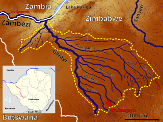
English: The Gwayi Basin OSM, Based up on US Army map SE35 |
| Ñalngu | |
| Sewnde | https://maps-for-free.com, http://legacy.lib.utexas.edu/maps/ams/africa_1m/, Location map:File:Zimbabwe adm location map.svg |
| Binnduɗo | Hans Braxmeier & Peter in s, Location map:NordNordWest |
This file is licensed under the Creative Commons Attribution-Share Alike 3.0 Unported license.
- Aɗa wellitii:
- e lollinde – e tummbitaade, saakde e ɓenninde golle ɗee
- e muultaade – e jaaɓtinde
- E ɗii-ɗoo sarɗiiji:
- fe'inana – You must give appropriate credit, provide a link to the license, and indicate if changes were made. You may do so in any reasonable manner, but not in any way that suggests the licensor endorses you or your use.
- lollin nannduɗe – If you remix, transform, or build upon the material, you must distribute your contributions under the same or compatible license as the original.
Aslol fiilde
Dobo e ñalngu/waktu ngam yiyde fiilde ndee no nde yaltirta e oon waktu nih.
| Ñalngu/Waktu | Dooɓre | Ɓete | Kuutoro | Yowre | |
|---|---|---|---|---|---|
| gonaaɗo | 11:43, 30 Duujal 2022 | | 567 × 425 (2,19 MB) | Peter in s | Kontrast, Lokation,... |
| 12:31, 6 Siilto 2019 |  | 567 × 425 (2,16 MB) | Peter in s | {{Information |description ={{en|1=The Gwayi Basin OSM}} |date =2019-09-06 |source =https://maps-for-free.com/ |author =Hans Braxmeier & Peter in s }} {{cc-by-sa-2.0}} Category:Maps of rivers of Zimbabwe Category:Drainage basin maps of Africa |
Kuutorgol fiilde
2 Ɗee kelle ena kuutoroo ndee fiilde:
Kuutoragol fiilde kuuɓtidinngol
Wikiiji ɗii-ɗoo goɗɗi ena kuutoroo ndee fiilde:
- Kuutoragol e af.wikipedia.org
- Kuutoragol e de.wikipedia.org
- Kuutoragol e en.wikipedia.org
- Kuutoragol e fr.wikipedia.org
- Kuutoragol e ha.wikipedia.org
- Kuutoragol e sn.wikipedia.org